Vegetation Assessment of Sclater’s Guenon Habitat in Ikot Uso Akpan Forest, ITU, Southeastern Nigeria 
2 Biodiversity Preservation Center, Uyo, Nigeria
 Author
  Correspondence author
International Journal of Molecular Ecology and Conservation, 2015, Vol. 5, No. 1 doi: 10.5376/ijmec.2015.05.0001
Received: 09 Dec., 2014 Accepted: 06 Jan., 2015 Published: 14 Feb., 2015
jacob et al., 2015, Vegetation Assessment of Sclater’s Guenon Habitat in Ikot Uso Akpan Forest, ITU, Southeastern Nigeria, International Journal of Molecular Ecology and Conservation, Vol.5, No.1, 1-6 (doi: 10.5376/ijmec.2015.05.0001)
This study was aimed assessing the vegetation structure of Sclater's guenon habitat in Ikot Uso Akpan forest, Itu, Southeastern Nigeria. Two sample plots (50m X 50m and 70m X 50m) were used for the vegetation assessment. Descriptive statistics and Computer program (Tree Draw and Stand Visualization System (SVS)) were used for the vegetation analysis. The result obtained showed that a total of 72 tree species belonging to 20 families was enumerated in the study area. Habitat degradation was severe in the study area negatively impacting on the habitat of the endemic primate species in the area. Urgent conservation measures are needed to restore and preserve the forest fragment to ensure the survival of the primate species in the study area.
Introduction
Biodiversity is the foundation of human existence as it constitutes the resource upon which virtually everyone depends, its conservation therefore becomes very pertinent (Groves, 2000). However, the modification of the ecosystem by human actions has threatened biodiversity at a global scale (Cowlishaw, 1999; Cowlishaw and Dunbar, 2000; Chapman and Peres, 2001). A report by the Food and Agriculture Organization quoted by Ettah (2008) indicate that tropical countries are losing 127,300 km2 of forest area annually. This does not include the vast area being selectively logged which is estimated to cover 55,000 km2 (Chapman and Lambert, 2000; Bennett, 2000).
In Africa, deforestation is a major problem, and natural habitat (e.g., lowland rainforest) is destroyed at a relative rate that is higher than those of other tropical regions (Archad et al., 2002). Furthermore, there is a prediction that an unabated continuation of the tropical forest destruction will result in the loss of about three-quarters of original forest cover by the turn of the next century (Archad et al., 2002). The issue is particularly serious because the tropics is the world’s highest ranking region in terms of species richness and endemism (Mittermeier et al., 1997;
Myers et al., 2000) and more than forty two percent (42%) of its biodiversity could be lost (Sohdi et al., 2004).
The Nigerian environment is presently exposed to factors that may induce species loss and decimation as a result of anthropogenic perturbation resulting from urbanization, agriculture, deforestation, industrialization as well as other sundry activities (Eniang, 2001; Eniang and Ebin, 2002; Egwali et al., 2005). Consequently, many mammalian species, especially the primates, are currently threatened at various levels which are inimical to their continuous survival. This study therefore examined the vegetation structure and constituent trees population density within the study area.
Materials and Method
Study Area
The study area is located in the southern part of Nigeria in Akwa Ibom State between 5º7’49’’ North and 7º56’47’’ East and lies between Ikot Uso Akpan and Obong Itam villages in Itu Local Government Area (Egwali et al., 2005). Itu Local Government Area occupies a landmass of approximately 606.10 km2 (onlinenigeria.com). It is bounded in the North and North-East by Odukpani in Cross River State and Arochukwu in Abia State, in the West by Ibiono Ibom and Ikono Local Government Areas, in the South and South-East by Uyo and Uruan Local Government Areas, respectively.
The vegetation of the area along the West and southern line is a swamp forest and moist lowland forest in the interline (Figure 1). The topography of the area is highly undulating. The area has eight to nine months of raining season and a short period of three to four months of dry season. The area has a mean annual rainfall ranges of 2500 to 3000 mm with a mean annual temperature of about 26.1 ºC and a relative humidity of 85% (Metz, 1992; Fasona and Omojola, 2005).
Figure 1 Map of Akwa Ibom State showing study area
Source: Egwali et al. (2005)
Data Collection
To enable an overview of the forest profile, a representative sample site within the forest fragments in the study area was examined. A two inventory plots of 50 × 50 m and 50 × 70 m within the community forest were established and their boundary delineated for data collection. Data collection was carried out between February and June, 2012 and the following parameter were collected for each tree with a diameter at breast height (DBH) of 10 cm and above as described by Quinten (2008); X/Y position within the plot using a simple tape measurement; DBH, circumference; Tree height; Bole height (height of first branch); Crown dimension; and Identification of the tree species.
Data Analysis
The enumerated plant species were classified according to their families. The mean population density per hectare of each species was determined from its population in the 1.8 ha area assessed and the total tree population per hectare was also computed using SVS©. Also, the profile of the sample plots were analyzed and displayed in a two dimensional view using the program ‘TreeDraw©’ Version 3.0 and Stand Visualization System (SVS).
Result
Vegetation Assessment
A total of 72 individual trees were recorded within the two sample plots belonging to 25 species and 20 families. Anacardiaceae and Moraceae had the highest number of trees present (10 trees) while Bignoniaceae, Lauraceae, Palmae and Burseraceae had one (1) tree species present respectively. The tree families and species are listed in Table 1 and all data for the two sample plots were subsequently processed to allow a visualization of the forest stand in the form of a forest profile (top view). The results of the exercise, based on the program TreeDraw© is shown in Figures 1 and 2.
Ber (Berlinia grandiflora), Ani (Anillopsis soyauxii), Spo (Spondias monbin), Mus (Musanga cercopioides), SAh (Autrenella congolensis), BAh (Ballionoiia toxisperma), Roth (Rothmannia longiflora), Xyl (Xylopia aethiopica), Dra (Dracaena manii), SEi (Celosia argentea)
Figure 1 An aerial view of the forest structure in Okuku fragment
Rauv (Berlinia grandiflora), Holar (Holarrhena floribunda), Ceiba (Ceiba pentandra), Ficus (Ficus thoningii), Spon (Spondias monbin), Homa (Homalium letestui), Dacro (Dacryodes edulis), Xylop (Xylopia aethiopica), Coelo (Coelocaryon preusii), Wei (Tetrapleura tetraptera), Macar (Macaranga barteri), Cinna (Cinnamomum zeylanicum), Eryth (Erythrina senegalensis)
Figure 2 An aerial view of the forest structure in Ikwat 1 fragment
Table 1 Tree inventory of Okuku forest and Ikwat 1
Okuku fragment tree inventory
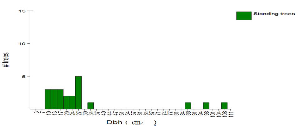
In the sample plot in Okuku forest fragment, a total of 23 trees were enumerated belonging to 10 families and 10 species. The smallest tree height in the sample plot had a diameter at breast height (dbh) greater than 10 cm was 6.8 m while the biggest tree reached a height of 27.8 m with a mean tree height of 11.8 m and a standard deviation of 6.1. The enumerated tree in the Okuku sample plot had a minimum dbh of 10.2 cm and a maximum dbh of 108.6 cm with a mean dbh of 33.8cm and a standard deviation of 31.9 (Figure 3). The total basal area of trees above 10 cm in the sample plot was 265.4 cm3 which is equivalent to 4623.6 per acre (Figure 4). Nineteen (19) of the sample trees were observed to belong to the height class of 5–15 m while the other two height class of 16–25 m and 26–35 m had two trees each respectively (Figure 5). However, Anillopsis soyauxii was observed to be the most dominant tree in the sample tree population with the highest frequency of 5 individual trees, followed by Berlinia grandiflora with a frequency of four individual trees while Autrenella congolensis, Ballionoiia toxisperma and Xylopia aethiopica had the least frequency of 1 individual trees each (Figure 6).
Figure 3 Height and crown size distribution of trees in Okuku fragment
Figure 4 Diameter class distribution of trees in Okuku fragment
Figure 5 Height distribution of trees in Okuku and Ikwat 1 fragment
Figure 6 Species distribution of trees in Okuku fragment
Ikwat 1 fragment tree inventory
In Ikwat 1, the sample plot contained a total of 49 trees belonging to 18 species and 16 families. The smallest tree height of dbh greater than 10 cm in the Ikwat 1 fragment was 5.9 m with a diameter of 12.1 cm and the tallest tree had a 24.9 m with a dbh of 56.8 cm (Figure 7). The mean height and dbh of the enumerated trees in the Ikwat 1 fragment was 25.5 cm and 12.0 m with a standard deviation of 10.3 cm and 4.3 m respectively (Figure 5). The total basal area of trees sampled in the plot was 242.5 cm3 (3523.4/acre) and the number of trees in the sample plot was equivalent to 853 trees/acre (Figure 8). Moreover, the dominant tree species in the sample plot was Ficus thoningii with a frequency of 10 individual trees, followed by Spondias mombin with a frequency of 8 individaual trees while the remaining 16 tree species had a frequency that varied between 5 and 1 individual trees each (Figure 9).
Figure 7 Height and crown size distribution of trees in Ikwat 1 fragment
Figure 8 Diameter class distribution of trees in Ikwat 1 fragment
Figure 9 Species distribution of trees in Ikwat 1 fragment
Discussion
The mean tree height in the sample plots was 11.8m, indicating a prevalence of relatively small trees inside the study area. More than 90% of all the sampled trees in the study area had a height between 0-20m compared to other tropical rainforest areas in the country such as Cross River National Park where the average continuous canopy height is between 30 to 35m (WWF, 1990). Moreover, despite the sporadic occurrence of trees with large diameter, trees with a small diameter clearly dominate the area with a mean diameter of 26.9 cm (Figure 4 and 8). The rather small dbh and height of trees in the study area could also be attributed the unsustainable exploitation of the forest resources in the study area. Furthermore, the presence of high tree density in the Ikwat 1 fragment than the Okuku fragments can be attributed to the presence of the sacred mound in the fragment and the marshy forest floor due to the sacred stream that flows in the fragment emptying itself in another fragment in the form of a water fall. The Okuku fragment is located on a upland and is less considered sacred as the Ikwat 1 fragment, hence, farm encroachment and logging activities is more severe in the fragment than the Ikwat 1 fragment (Jacob, 2012; Egwali et al., 2005).
Moreover, the forest fragments are located in economically poor communities with a high population growth rate in the area. The people depend directly on the available resources such as land for their subsistent agriculture (Baker, 2005). This does not augur well for forest protection (Chapman et al., 2006) which serves as the habitat for the endemic primate species (Cercopithecus sclateri) in the area. However, not all the habitat changes in the study area are due to human activities. Other factors include changes such as wind throws and tree dieback due to cohort senescence. Consequently, all of these factors affect the vegetation structure of the study area, thus impacting on the primate populations negatively (Ibong, 2002; Baker, 2005; Egwali et al., 2005; Jacob, 2012).
Plate 1 Scenes of deforestation in the study area
Source: Field survey, 2012
Conclusion
The impact of indiscriminate logging, forest resources exploitation and agricultural conversion on the study area is severe leading to gaps and juvenile or few mature trees in the study area. Although the area is still covered with patches of more or less intact rainforest species with small diameter and height, logging has negatively impacted on the species composition of the study area. Furthermore, increased pressure for suitable land for crop cultivation by the local community members has also resulted in the clearance of the forest edge for fertile land to cultivate their crops. The accessibility of areas which were formerly difficult to get to has improved considerably increasing exploitation and vegetation degradation of the forest resources. There is therefore the need for an effective management strategy to be implemented the study area to restore and control the rate of vegetation degradation to ensure sustainable forest resources exploitation in the area and also to safeguard the habitat of the endemic primate species.
References
Akwa Ibom State, 2011, www.onlinenigeria.com/Akwa+Ibom
Archad F., H. D. Eva, H. J. Stibig, P. Mayaux, J. Gallego, T. Richards, and J.P. Mailingreau, 2002, Determination of Deforestation Rates of the World's Humid Tropical Forest, Science, 297: 999-1002
http://dx.doi.org/10.1126/science.1070656
Baker L. R., 2005, Distribution and Conservation Status of the Sclater's Guenon (Cercopithecus sclateri) in Southern Nigeria. Report to Margot Marsh Biodiversity Foundation, Rufford Small Grants, Lincoln Park Zoo Department of Conservation and Science, American Society of Primatologists, Sigma Xi, National Science Foundation, and Stanford Bay Area Charities, pp: 23
Bennett E. L., 2000, Is There a Link Between Wild Meat and Food Security? Conservation Biology, 16: 590-592
http://dx.doi.org/10.1046/j.1523-1739.2002.01637.x
Chapman C.A., and J.E. Lambert, 2000, Habitat Alteration and the Conservation of African Primates: A Case Study of Kibale National Park, Uganda. American Journal of Primatology 50: 169-185
http://dx.doi.org/10.1002/(SICI)1098-2345(200003)50:3<169::AID-AJP1>3.0.CO;2-P
Chapman C.A., and C.A. Peres, 2001, Primate Conservation in the New Millennium: The Role of Scientists. Evolutionary Anthropology 10: 16-33
http://dx.doi.org/10.1002/1520-6505(2001)10:1<16::AID-EVAN1010>3.0.CO;2-O
Chapman C. A., Lawes, M. J., and Eeley, H. A. C., 2006, What Hope for African Primate Diversity? African Journal of Ecology, 44: 116–133
http://dx.doi.org/10.1111/j.1365-2028.2006.00636.x
Cowlishaw G., 1999, Ecological and Social Determinants of Spacing Behavior in Desert Baboon Groups. Behavioral Ecology and Sociobiology 45: 67-77
http://dx.doi.org/10.1007/s002650050540
Cowlishaw G., and R.I.M. Dunbar, 2000, Primate Conservation Biology, University of Chicago Press, Chicago
Egwali E.C., R.P. King, E.A. Eniang, and E.A.Obot, 2005, Discovery of New Population of Sclater's guenon (Cercopithecus sclateri) in the Niger Delta Wetland, Nigeria, Liv. Sys. Sus. Dev., 2(4): 1-7
Eniang E.A., 2001, Effect of Habitat Fragmentation on the Cross River Gorilla (Gorrilla gorilla dehli): Recommendations for Conservation, Unpublished report submitted to the Cross River National Park, Akamkpa, Nigeria, pp: 30
Eniang E.A., and Ebin C.O., 2002, Utilization of Confiscated Animals by Cross River National Park to Promote In-Situ Biodiversity Conservation in the Rainforest of Southeastern Nigeria. In: The Proceedings of Pan African Association of Zoological Gardens, Aquaria and Botanical Gardens (PAAZAB) Annual Conference, 28th-31st May, 2002. Johannesburg, South Africa, pp: 17
Ettah U.S., 2008, Conservation Strategies of Cross River gorilla (Gorilla gorilla diehli) in the Afi Mountain Wildlife Sanctuary of Cross River State, Nigeria, An Unpublished M.Sc. Thesis submitted to the University of Uyo, Uyo, pp: 72
Fasona M.J., and Omojola A.S., 2005, Climate Change, Human Security and Communal Clashes in Nigeria. Human Security and Climate Change, An International Workshop, Asker, Norway, Unpublished Conference Paper, pp: 13
Groves C., 2000, The phylogeny of the Cercopithecoidea. In: Whitehead, P. and C. Jolly (eds.) Old World Monkeys, London: Cambridge University Press, pp: 92-95
http://dx.doi.org/10.1017/CBO9780511542589.005
Ibong B. U., 2002, Ecology and conservation of the primate Sclater's guenon (Cercopithecus sclateri) in Itu Local Government Area of Akwa Ibom State: Population Structure, Undergraduate Project submitted to the University of Uyo, Uyo, pp: 48
Jacob D.E., 2012, Population and Habitat Assessment of Sclater's Guenon (Cercopithecus sclateri, Pocock 1904), In Ikot Uso Akpan Community Forest, Itam, Akwa Ibom State, Nigeria, An Unpublished M.Sc., Thesis submitted to the University of Uyo, Uyo, pp: 116
Metz, H.C. (Ed.), 1992, Nigeria: A Country Study, Federal Research Division, Library of Congress, Washington, DC
Mittermeier R.A., N. Myers, P. R. Gil, and C.G. Mittermeier, 1997, Hotspots: Earth's Biologically Richest and Most Endangered Terrestrial Ecoregions. Cemex, Conservation International and Agrupacion Sierra Medre, Monterrey, Mexico, pp: 58


. PDF(463KB)
. FPDF
. HTML
. Online fPDF
Associated material
. Readers' comments
Other articles by authors
. D.E. Jacob
. E.A. Eniang
. I.U. Nelson
. U.I. Udoakpan
Related articles
. Lowland rainforest
. Vegetation structure
. Conservation
. Sclater‘s guenon
. Nigeria
Tools
. Email to a friend
. Post a comment